
Descriptions of features at Körösladány-Bikeri
Item record
Documentation
Excavation Techniques and Documentation Methods
Initially, test excavation units were opened at both Bikeri sites based upon the information we collected during intensive surface collections, geophysical surveys, and geochemical studies (see Chapters 4 to 7). Subsequently, we conducted larger excavations that expanded upon the results of the test excavations. Six week field seasons occurred during June, July, and August from 2000 to 2003 and in 2005 and 2006. Formal study seasons were carried out in 2004 and 2007, and additional specialist analyses were performed in subsequent years. Our excavation methods at Vésztő-Bikeri and Körösladány-Bikeri combined micro-stratigraphic and alternating block grid techniques, which provided detailed observations and documentation of spatial relations between features and cultural materials in fills, middens, and other contexts. With the micro-stratigraphic technique, features, cultural layers, and construction, destruction, floor, and walking levels were excavated, while alternating block grids were used to produce cross-sections at close intervals. These cross-sections then were used to guide later excavations that followed natural stratigraphy. Individual excavation units (EUs) were designated by excavation block number followed by an individual unit number (for example, EU 1-10, EU 4-22); this numbering system reflects the sequential order of how units were opened within each excavation block. Feature numbers were assigned sequentially as features were identified at each site. Because some features, such as ditches and palisades, extended into multiple excavation blocks, feature numbers were not separated by excavation block. Starting and ending elevations for each EU and features were recorded in meters above sea level with a total station. The northings and eastings used during the excavation were recorded using the Pulkovo 1942 projected coordinate system.
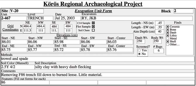
The upper part of the plowzone in the excavation blocks, typically 25–35 cm in depth, was removed by spades (in smaller test trenches) or by machinery (in larger excavation blocks) in units of various sizes, depending on the extent of the excavated surface. The base of the plowzone was exposed by hand tools to identify the top of the intact cultural layer, which always extended up into the plowzone. Because units in the plowzone were disturbed, the excavated sediments from those units were not sifted and flotation samples were not taken, but artifacts were collected by hand. Whenever possible, excavation below the plowzone followed natural stratigraphy. When features were encountered, the EU was leveled off at the elevation where the top of the feature was first observed. In situ finds were plotted, photos were taken, and a plan map was drawn at that elevation. When possible, individual fill layers of features were removed as separate EUs. When natural layers could not be identified within features, the fill usually was excavated in arbitrary 10 cm levels. When possible, we sectioned features and excavated each half separately. After the stratigraphy was defined, photographs were taken, and a profile map was drawn, the remaining half of the feature was excavated by natural stratigraphic layers, with a separate EU number given to each layer of the feature fill. In ditches and wall trenches of buildings, separate EUs for each 1 m-long segment were assigned.
When features were not identified, the cultural deposit was excavated in 1 x 1 m, or occasionally 2 x 2 m, squares. If no change in natural stratigraphy was detected, a depth of 10–15 cm was removed within the squares at one time and recorded as a separate EU. Alternate quadrants also were used; this provided cumulative profiles in each square that were used to guide the excavations in adjacent squares. The number and weight of artifacts, faunal remains, and other objects were recorded by EU in the field. This permitted us to produce density maps with a high degree of spatial resolution. With few exceptions, sediments excavated below the plowzone were sifted through dry sieves with 6 mm (¼-inch) galvanized hardware cloth mesh, and flotation samples of at least 10 l were taken from every EU to recover small artifacts and small floral and faunal remains. When possible, feature fills were floated in their entirety. When human burials were encountered, the limits of the burial pit were defined and the skeleton and associated grave goods were exposed. The burial was photographed and mapped, and grave goods were piece-plotted before they were removed.
Paper EU forms were used to record data in the field. Information on the forms was entered into the excavation database in the lab at Vésztő. The site, block, and EU numbers were listed on each EU form, along with the stratigraphic context, date, and the initials of the excavators. The grid coordinates that defined each EU also were entered, along with the dimension of the EU, the target depth, and the starting and ending elevations for each corner as well as the center point of the EU. The method of excavation (such as backhoe, spades, or trowels) also was recorded. It was noted whether the excavated sediment was sifted or not. Sediments were described, and Munsell color designations also were provided in the EU forms. The presence of different types of cultural materials (for example, ceramic, daub, lithic, metal) and faunal and floral remains was noted for each EU.
The EU form also was used to record the field weight of the recovered daub and ceramics. These artifacts were weighed with spring scales in the field. All ceramic sherds were collected, but only a representative sample of daub (usually several pieces, particularly ones with wattle or other organic impressions) from each EU was kept for further analysis. The different types of finds were placed in separate paper or plastic bags. Separate bags were used for in situ clusters of cultural materials. When excavation of a unit was complete, the total number of bags collected was entered on the EU form.
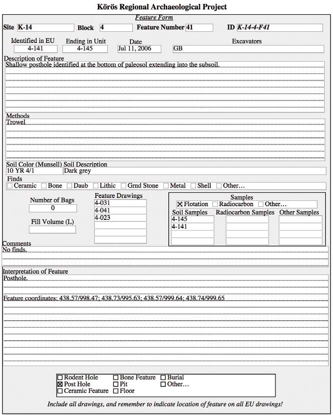 The kinds of samples (flotation, radiocarbon, and soil chemistry) taken from each unit were noted. There also was room on the form for excavator’s comments, information about photographs and drawings as well as features associated with the particular EU. Separate field forms were used to record information about features exposed in the blocks. Each settlement and burial feature, as well as artifact concentration, was provided with a separate feature number. Feature forms listed the site, block, and feature number, the EU numbers where the feature was identified and ended, the date when the feature was discovered, and the initials of the excavators. The excavation methods, sediment descriptions, finds, samples, photographs, maps, and drawings also were entered on the feature form. There was room for a description of the feature, including its grid coordinates and starting and ending elevations. The interpretation of the feature was written on the form, and the plans, profile drawings, and maps of the feature were attached to the feature form. This information also was entered into the feature log for each site and into the project database (see Appendixes IV to VI, this volume).
When the bags from the EUs and features were checked in at the field lab in Vésztő, the counts and weights of the various artifact types were recorded for each EU on washing forms. Ceramics and lithic artifacts were washed with water. Metal, bone, and shell items were cleaned with dry brushes and wooden picks. Cultural materials were labeled before the initial identification, classification, and analyses were completed. Additional databases and spreadsheets were used for the specialized analyses of the various types of finds. FileMaker Pro software was utilized to create and manage the main databases for the project.
Reuse
Yerkes, Richard W., 2021. Appendix VI: Descriptions of features at Körösladány-Bikeri for Bikeri: Two Copper-Age Villages on the Great Hungarian Plain. Version 1. Cotsen Institute of Archaeology Press. https://doi.org/10.25346/S6/ZL2YRL